

UAF researcher sails north in search of deep-sea answer
August 11, 2021
Rod Boyce
907-474-7185

Coakley will be looking to explain the formation of the large Arctic Ocean feature known as the Amerasia Basin. It and the Eurasia Basin are the two basic sub-basins of the Arctic Ocean.
Current knowledge about the Amerasia Basin’s formation comes only from observations of adjacent continents and assumptions about tectonic activity.
“For the last 50 or more years, everywhere else in the world we first learn what's going on in the ocean and then suddenly can make sense of the continents,” he said.
“Because we don't understand how the Arctic Ocean was formed, we're kind of stuck working backward in the Arctic, where we've been standing on the edge of the ocean, we say, ‘Well, I see this over here and this over here, and therefore the ocean is this.’”
Coakley and others — 23 in the science party and about 20 crew — left the port of Seward aboard the Sikuliaq at about 8 p.m. Tuesday. They are scheduled to arrive in Nome in mid-August, take on additional fuel and supplies, then continue north to the Arctic Ocean’s Amerasia Basin.
Their destination is the Chukchi Borderland, a block of extended continental crust of about 77,000 square miles embedded in the deep-water Amerasia Basin.
Coakley and the science party onboard Sikuliaq will venture into the Arctic Ocean to try to understand the basin’s development by observing the relationships among the adjacent geologic features.
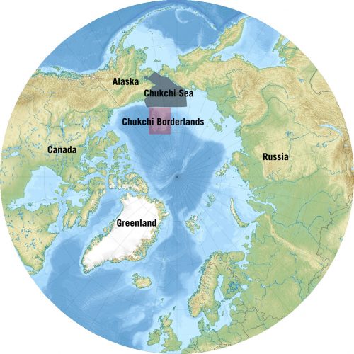
They aim to map the northern edge of the Chukchi Borderland as well as the adjacent Canada Basin, a component of the Amerasia Basin that lies north of Alaska and Canada.
Plate tectonics study of the oceans has taught us that “to understand the opening of this basin, it is necessary to restore the borderland to its pre-opening position,” he said.
The odd thing about the Chukchi Borderland — and something Coakley hopes to resolve — is that analyses of it have not been able to restore it to any of the nearby continental shelves. That makes the borderland different from other examples of continental crust stranded within oceanic crust.
“Uncertainty about the evolution of the Chukchi Borderlands has been, in part, due to the limitations on collecting geophysical data in the Arctic Ocean,” the project proposal reads. “In the last decade, this situation has changed dramatically.”
The mission builds on that recent increase of research by others.
Coakley’s team will collect multichannel seismic reflection data, giving researchers information about the stratification and structure of the crust. This can be “read” to reveal the history of the basin. Seismic refraction data will also be collected, using ocean bottom seismometers and buoys with sonar systems to determine if the crust is oceanic or continental.
Coakley has made several research trips to the Arctic Ocean, including as a member of the civilian scientific team aboard the U.S. Navy submarine USS Pargo in 1993, while at Lamont-Doherty Earth Observatory in New York. That mission was the first civilian oceanographic submarine cruise of the Arctic Ocean.
The six-week voyage on the USS Pargo began at Naval Submarine Base New London in Groton, Connecticut. It ended in Bergen, Norway. During this trip around the Arctic Basin, they collected data about the bathymetry of the Arctic Ocean and about its water and ice.
The voyage and subsequent voyages during the Submarine Arctic Science Program, or SCICEX, contributed to the creation of the first detailed chart of the Arctic Ocean depths four years later.
“From the International Bathymetric Chart of the Arctic Ocean, we have a fairly good description of the seafloor on the Arctic Ocean,” he said.
So why go back?
"We don’t have good explanations for how these basins formed."
ADDITIONAL CONTACT: Alice Bailey, UAF College of Fisheries and Ocean Sciences public information officer and R/V Sikuliaq science liaison, 907-328-8383 , alice.bailey@alaska.edu