Scientists from both the U.S. and Russia are using less invasive technology to get a more complete survey of the walrus population in the Bering Strait region. Their updated methods of surveying could lead to better management and protection of the subsistence marine mammal.
Tony Fischbach is a wildlife biologist with the U.S. Geological Survey Alaska Science Center. He’s been collaborating with scientists from the Russian side of the Bering Strait to test newer methods of surveying walrus on both sides of the Strait.
“With the help of Anatoly Kochnev and a team of biologists working there (in Chukotka), they were able to monitor five different sites using drones, and they also did controlled experiments in places where there weren’t too many walruses to determine what altitude the walruses will tolerate,” Fishbach stated.
The partnership helped scientists determine that if they flew a drone less than 50 meters above the head of a walrus, the walrus would be disturbed and flee, Fischbach said during a Strait Science presentation hosted by the University of Alaska Fairbanks Northwest Campus in Nome. But if the drone was flown higher than that height, then they would be able to safely conduct their surveys.
Current aerial surveys that his team does with drones are flown at 100m above walruses so as to be doubly sure they don’t disturb the marine mammals, according to Fischbach.
Overall, Fischbach believes relying on this method rather than aerial surveys in small “bush” planes flown by private pilots is the better option.
“It’s much, much safer, not only for humans, but much safer for walruses. The best thing for us, is you can get more data. Whenever the weather breaks, the rain stops, and lays down, we can get out of our tents, launch this thing, get the survey done, and do it safely,” Fischbach said. “And the data is better too.”
Fischbach’s research team was able to fly 26 drone surveys in a span of two years to count walruses. That’s compared to the old method of flying planes for aerial surveys a few times a year which was limited by costs, weather, and seasonal challenges.
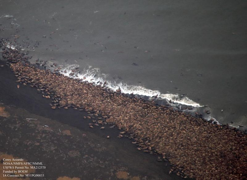
Thanks to drone surveys, they were able to release “defensible numbers” from their annual walrus count at a previous Point Lay haul out, Fischbach said. The team estimated almost 60,000 walruses were on the beach during surveys taken at Point Lay in the fall of 2018 and 2019.
Once Fischbach and his team combine the survey data with information gathered from radio telemetry tags, they placed on a number of walruses, then he says they will have a fuller picture of the regional population.
“And now that we have this methodology worked out, we can collaborate with partners in Northern Chukotka,” Fischbach said. “If they are interested, we can build a team, and we can do an estimate for the entire Chukchi Sea during that open water period.”
Anatoly Kochnev is one of the scientists who has been doing similar drone surveys on the Chukotka side of the Strait since 2017 and studying walruses for decades. Kochnev has also conducted aerial surveys of walrus, as well as focused on the local polar bear population in Chukotka for 30 to 35 years.
Kochnev told KNOM via email: “The Pacific walrus is our shared resource, and Russia and the US need to work together to effectively manage and conserve the population. Therefore, I really hope for continued cooperation. I think we need to focus on developing a simple and reliable method for regularly estimating population size – for example, using satellites is exactly what Tony [Fischbach] is doing right now. I would also like to continue monitoring the land walrus haulouts. In addition, we need to focus on tracking changes in the population associated with climate change.”
His and other Russian scientists’ involvement hinges on the 1994 re-negotiation of the U.S.-Russia Environmental Agreement to cooperate on environmental issues of mutual interest and concern.

As scientists from both sides of the Strait gather better survey data of walruses, this data could be used to inform management practices for U.S. and Russian agencies, for example the US-Russian Marine Mammal Working Group, and also to protect the tusked animals from increasing vessel traffic.
Fischbach pointed to numerous ships transiting up and down the Chukotka side of the Bering Strait, mostly going in and out of the Sea of Okhotsk.
“The main thing is that we’re able to provide near-real-time management information and let people know ‘oh, take that different approach,’ so don’t fly over them [the walrus] for the aviators. And the same thing for mariners. That can be provided to authorities and they can give advice to people. It can also be used to support haul-out based estimates we were working on before,” Fischbach explained.
One of the next goals for Fischbach and his research team is to do future population estimates of walrus using satellite imagery counting the animals directly from space.
The U.S. Fish and Wildlife Service does not yet know when they will do an updated survey of the Chukchi Sea walrus population, according to Fischbach.
Image at top: Thousands of Pacific walrus gather on shore near Point Lay in 2014. Photo from Corey Accardo, NOAA, used here with permission.