Run Uphill for a Tsunami, Downhill for a Landslide
Following fatal landslides, the town of Sitka, Alaska, worked with scientists to create a new, individualized hazard warning system, revealing the complexities of coproducing knowledge.
Historic Sitka, Alaska, a town of 9,000 residents, is located on an island southwest of the state capital of Juneau, in the heart of the Tongass National Forest. The Pacific Ocean borders one side of the town, with steep mountains rising above the other. The community has long recognized the threat of tsunamis, but heavy rains in recent years have now caused landslides to be a concern as well. This is the story of how Sitka came to build its own innovative landslide warning system, as told by members of the team working to develop it.
August 18, 2015: Rain all morning
Sitka Sound Science Center’s Lisa Busch: When four inches of rain fell on Sitka before 9:00 a.m., we knew it was not going to be a typical rainy day. The town has a well-functioning tsunami warning system, but had previously experienced few landslides, even though we get about 100 inches of rain a year. So when mud began to move down the hillsides around the town, there were no warnings. Three people died, a house was destroyed, and a lot of city infrastructure was damaged. Volunteers and city workers immediately went to work with shovels.
At the Sitka Sound Science Center, the community-based nonprofit field station where I’ve worked for the past 11 years, we realized we needed to quickly learn enough about landslides to help community members feel safe in a landscape that was literally shifting under our feet.
The pursuit of answers to this question would grow into an innovative collaboration between the community and a diverse group of scientists to create a unique landslide warning system that is tailored to Sitka’s needs, integrating cutting-edge research from both the physical and social sciences.
While most warning systems are hazard-centered and top-down, the collaboration has codesigned something unique. Using sensors in the hillsides to anticipate potential landslides, our decentralized warning system lets individuals make their own judgments about risk. Through the process, the community taught us—their scientist partners—to think about agency, trust, information, and even geoscience in new ways. Sitka’s warning system serves as a model of community-driven climate adaptation, while also offering an intriguing picture of how such collaborations may reenvision the way scientists and governance work.
Fall 2015: A research agenda powered by anxiety
Landslides are a particularly nerve-wracking kind of hazard. Predicting them is an imperfect science. But more than that, once a slide starts near Sitka, a person might have less than a minute to get out of its way.
In response to community questions about these new hazards, the Science Center convened a group of geoscience experts to meet a few times a week by phone to get answers. From that informal group of 30, the Sitka Geotask Force coalesced to include experts drawn from the National Park Service, US Forest Service, US Geological Survey, University of Alaska, City of Sitka, Alaska State Division of Geologic and Geophysical Services, Sitka Tribe of Alaska, National Weather Service (NWS), and NASA.
Using sensors in the hillsides to anticipate potential landslides, our decentralized warning system lets individuals make their own judgments about risk. Through the process, the community taught us—their scientist partners—to think about agency, trust, information, and even geoscience in new ways.
In the weeks and months immediately following the August 2015 landslide, new anxieties emerged in our community and prompted new questions. Should we send our children to school on heavy-rain days? Whose responsibility would it be to call a “rain day” and cancel school? What information would we need to be able to predict landslides? How safe are the housing developments in steeply sloped neighborhoods? What will this new concern mean to land values and the availability of insurance?
Angst and anxiety, we soon came to realize, would drive the questions, methodology, and forward momentum of the entire project.
September 2017: Building knowledge about a stochastic hazard
The first workshop sponsored by the City of Sitka was titled “What questions could we answer that would help make people feel less anxious about landslides?” The Science Center briefed the scientists from the Geotask Force to motivate them to focus on the concerns of the town, acknowledge that scientists don’t have all the answers, and be prepared to integrate local knowledge.
During the workshop, a representative from NWS encouraged the town to create a landslide warning system. Sitka’s tsunami warning system is a siren system activated by the fire chief as advised by the National Tsunami Warning Center. The idea took hold that we could create a centralized warning system building upon the one established for tsunamis.
However, designing a warning system for landslides is notoriously complicated. Landslide processes are stochastic, meaning that a landslide may occur once in a generation, never, or many times in difficult-to-predict locations. We realized our research needed to combine multiple types of knowledge, spanning wide temporal and spatial scales: scientific knowledge and expertise from the observation of various landscapes, local knowledge of Sitka in the present day, and long-term knowledge of the relationship between people and the landscape over generations. By combining all three types of knowledge, we could improve our understanding of landslide processes, hazards, and human relationships with the natural landscape.
Representatives from the Sitka Tribe of Alaska, the local tribal government, helped with the long-term knowledge by gathering oral histories from Tlingit tribal citizens that revealed a deep history of human migration tied to flooding and natural hazards. As a coastal people, the Tlingit told stories about how settlement selection was driven by proximity to food sources, particularly fish, which could be found in the ocean and rivers. Guided by longstanding Indigenous values that emphasize careful observation of the natural world, people did not traditionally build near landslide zones. The stories revealed that the responsibility of building a house to stand for generations to come required close attention to the natural environment.
February 2018: Designing a warning system that won’t cry wolf
Risk management researcher Robert Lempert: When an opportunity arose to work with Sitka to apply for a grant to build a warning system from the National Science Foundation’s (NSF) Smart and Connected Communities Program, I jumped at the chance. Much of my scientific research at the RAND Corporation has focused on informing participatory processes for climate adaptation in large communities such as Los Angeles, in which stakeholders are represented by technical experts. Sitka’s need for a warning system provided a rare opportunity to explore directly participatory risk governance with people in a small community.
The Science Center organized a week of meetings and events to increase awareness and advertise our presence in the community. Our team made short presentations to the Sitka Assembly (the city council) and school board, and we were interviewed on the local radio station.
I’m really interested in how scientists can work with communities while ensuring that those communities have agency—both in the questions science asks and how the answers are used. Agency (defined as the capacity to make free choices) is important because determining good and appropriate uses of science depends on what a community values. In the coproduction of science, these needs must be balanced with the need for high-quality science and the independence of scientific inquiry.
Our goal was to learn from the community. Our week of meetings included those with the Sitka Tribe of Alaska, department heads for the City and Borough of Sitka, the fire chief and other emergency planners, and the business community. Each discussion was organized as an open-ended interview, where we asked people what landslide risks they perceived, their sources of information on landslides, how they currently respond to landslide and other risks, what they wanted from a warning system, and what they might want from our project.
And nearly every morning, we went to a local coffee shop, where community members would drop by. As we got to know people in town, we often heard fascinating and heartfelt stories. The town’s commercial fishers proudly described the way they self-insure their boats. A resident told us how he survived a landslide on a camping trip: standing outside his cabin, he heard a sound, looked up the hill, and with just 10 seconds of warning managed to outrun the landslide, ending up in the ocean, surrounded by a mass of twisted logs.
From these discussions and our understanding of the scientific opportunities, we began to see a basic structure for an interdisciplinary research project among RAND, the Sitka Sound Science Center, the Sitka Tribe of Alaska, the University of Oregon, and the University of Southern California. We decided to combine geoscience, information science, social science, and risk management components to create a warning system for the town, built on its current hazard warnings, which were centered around the fire chief.
We planned to use geoscience to identify risky moments and deliver a medium-term warning, so people had time to evacuate. We also saw an opportunity to significantly improve landslide prediction by using newly inexpensive Internet of Things moisture sensors placed directly in the hills to determine when local conditions suggested a slide was imminent. Citizen science efforts would provide additional data and further involve the community in the project. And to make sure the word got to all of Sitka’s citizens, we planned to use social network analysis to understand how to send warnings by text or social media without leaving anyone out.
Even once we got all of these systems up and running, we would still have to grapple with a big problem with landslide warnings: it’s very hard to balance protecting people from harm against inadvertently “crying wolf” with well-meaning but too-frequent warnings. My work, called deliberation with analysis, planned to use landslide risk maps to involve the community in the process of deciding which trade-offs they were comfortable with so that we could incorporate their preferences into the design of the warning.
There’s a big problem with landslide warnings: it’s very hard to balance protecting people from harm against inadvertently “crying wolf” with well-meaning but too-frequent warnings.
But the sense that we had more to learn from the community came on our last full day in town, when I realized how differently community members perceived what was at risk from landslides. That day, we met with a group of realtors concerned that an undue focus on landslides would make it harder to get mortgages and insurance, harming the community and its independence. After a spirited discussion, the senior member of the group, who had not yet spoken, asked if we recalled the biblical story of Adam and Eve. Too much knowledge, he said pointedly, had expelled the pair from paradise. This Sitkan trusted his fellow residents to make responsible decisions about risk, but worried that outside insurers and bankers would not.
February 2019: Modeling a skeptical social network
Social scientist Max Izenberg: Soon after NSF funded the project in October 2018, I went to Sitka. I quickly realized that if we wanted to do a good job with the warning, we would need to think as deeply about trust as we do about geo hazards. As a social scientist, I know that a tenet of risk communication is that an effective warning system is redundant and targeted, and disseminated from a credible source. The last part is the most challenging: Credible to whom? Could one person’s credible source be dismissed as untrustworthy by another?
What I quickly discovered was that although Sitkans wanted to be sure that future landslides didn’t result in tragedies, residents were reluctant to share the names of people in their social networks, which we needed in order to analyze how information flows in the town. This analysis would help us ensure that warning text messages and other outreach methods reached everyone. Justifiably, many Sitkans were suspicious and felt uneasy about our request.
This meant that achieving a comprehensive sample of all Sitkans and their social networks would be nearly impossible. And given that, could we be sufficiently confident that any insights we gained from a partial survey were up to the task of hazard warnings? Many researchers consider partial network data to be a trade-off. We could either have genuine conversations with Sitkans about their networks and theoretically accept holes in the network, or we could leverage existing data sources and build synthetic models and compromise the human component. In order to apply community-partnered research and social science theory in a meaningful way to Sitkans, building trust was foundational to ensuring quality and relevant insights. Consequently, instead of viewing this as a trade-off, we opted for a third way that did not strictly follow either of the two options. Holding genuine conversations was both a means and an end: by building trust with Sitkans, we were able to unlock a better understanding of the unique social dynamics of Sitka that no model could have ever estimated.
Holding genuine conversations was both a means and an end: by building trust with Sitkans, we were able to unlock a better understanding of the unique social dynamics of Sitka that no model could have ever estimated.
We started by identifying various communities, not only to identify variation in landslide warning system preferences and social networks, but also to build community-level trust. Sitka is home to many overlapping communities, including Alaska Natives, commercial fishermen, former loggers, retirees, and many others. Historical legacies of exploitation and deception as well as contemporary politics have engendered suspicion of “experts” and researchers from the Lower 48. After multiple survey promotion attempts, we were effectively able to map over 60% of Sitka’s “informal” landslide communication network.
In the process of listening and engaging with community members, we were better able to understand their skepticism and identify what aspects of the landslide research initiative community members would find valuable. Spending time in Sitka allowed us to collate diverse forms of knowledge. In line with Alaskans’ independent spirit, we wanted to ensure that each Sitkan can rely on receiving landslide risk information in a way that “meets them where they’re at.” I felt that the community-based approach to data collection was hardly a trade-off and really helped ensure Sitkans’ confidence in our findings.
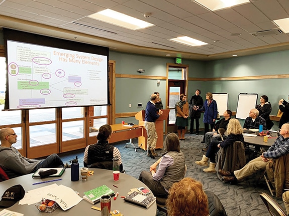
May 2019: Determining what makes an exemplary warning system
Rob Lempert: With the project in full swing, the project team returned to Sitka for workshops focused on designing the warning system. We used “backcasting” to help community members tell stories about their aspirations for successful warning. Organized into small groups, citizens, local officials, and state and federal scientists imagined that it was the year 2025, and Sitka had become famous for its exemplary landslide warning. What would they say to visitors about what they found most valuable with the system? What would they say about how the community had come together to create it? This storytelling helped community members articulate their criteria for a successful warning system, which included trustworthiness, low cost, and one designed to avoid confusion. When people heard the alarm, would they know to run uphill for a tsunami or downhill for landslide?
June 2019: Putting sensors in the hills
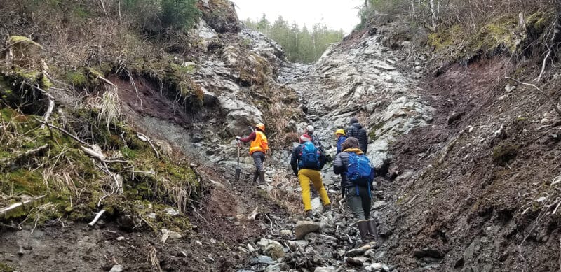
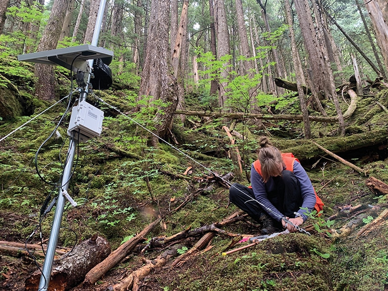
Geologist Annette Patton: As a geologist, I joined this project to install a prototype hydrologic sensor network on the slopes above Sitka and evaluate landslide hazards. In the town’s dramatic, glacially sculpted valleys, my collaborators and I were eager to shake up the rules about who could afford new types of monitoring technology, which we hoped could save lives.
We installed three hydrologic monitoring stations equipped with soil moisture sensors, a groundwater well, a rain gauge, and humidity and temperature sensors. Programmed to take readings every five minutes, they used long-range radio to transmit every observation to a nearby receiver. Best of all, with a hodgepodge of cheap and self-manufactured components assembled by an engineering student at Oregon State University, they were one-tenth the cost of similar commercially available systems.
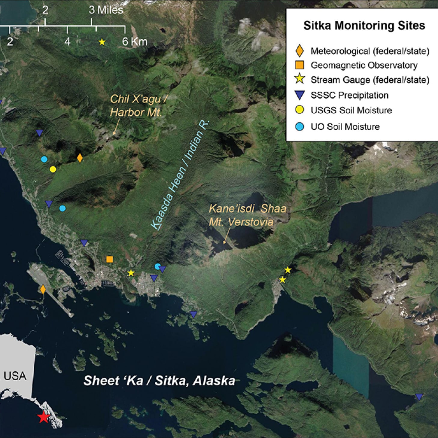
Rainfall and soil hydrology monitoring stations installed around Sitka, including equipment operated by state and federal agencies prior to this project.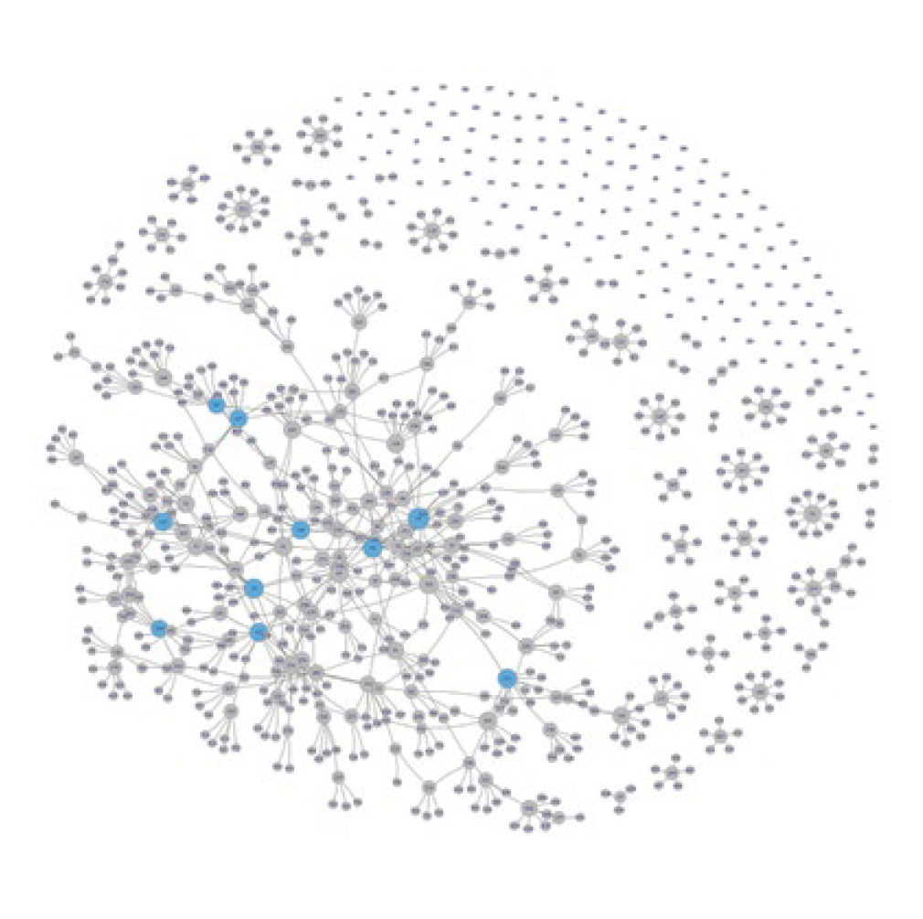
Sitka’s informal landslide communication network.
What I remember most about that trip was the curious and engaged human landscape of the community impacted by landslides. Sitkans came up to us in the pizza shop with questions about our science. The local radio station interviewed our team, wanting to spread the word about landslide warning systems. Our collaborators at the Science Center and the US Forest Service supported our field installations and created opportunities for us to meet the community.
During one meeting with the police and fire chiefs, they expressed concern about how we planned to structure a warning system. They could envision scenarios in which our models might suggest that landslides were imminent, causing the city to evacuate large areas, yet no landslide occurred. Not only do such mitigation efforts incur substantial financial cost, but false warnings cause a community to lose faith in a system that too often “cries wolf.” Furthermore, we realized that even if we correctly forecasted a landslide that had no impacts to people or infrastructure, the residents who evacuated their homes might not consider that a successful outcome. This was when I started to wonder whether the top-down warning system we’d been imagining was the best design.
This moment also made me aware of the importance of identifying how academic metrics of success differ from community needs. As a scientist, I understand that my perspective skews towards unbridled curiosity about the natural world. What are the mechanics of landslide initiation? When did glacier ice retreat from this valley?
I started to wonder whether the top-down warning system we’d been imagining was the best design.
While the majority of Sitkans share my curiosity on these and other questions, they also have a real stake in the outcomes of catastrophic events, so they also have a suite of very practical questions: Is my house in a safe place? How about my kids’ school? Is this storm big enough to cause a landslide? If so, can I react in time to keep my family safe?
These questions inspired us to explore information in new ways. A collaborator produced a model that used topography to predict where landslides might initiate. With his model and the multiple monitoring instruments sprinkled across the hillslopes, we can measure the variability in conditions that influence the likelihood that a landslide will occur. Not only does this work describe the form and processes at play in a complex landscape—satisfying my academic curiosities—but it also indicates how to interpret our measurements for better forecasts. While a zoomed-out view may be frustrating to residents who are concerned about their individual homes or properties, this knowledge allows our team to more effectively communicate uncertainty in hazard and risk and pursue realistic but useful mitigation strategies.
The process of developing knowledge through the collaboration of local residents and scientists has grown over the course of the project. During an interview, a local radio host guided the geoscience team to an unofficial trail that improved access to one of our monitoring sites. Volunteers hosted a network of 10 rain gauges in people’s backyards that collect information about how rainfall varies across town during a storm. The local search and rescue team hauled weather station equipment to the top of a mountain. Representatives of the Sitka Tribe of Alaska also helped us by sharing traditional names for places in the land and knowledge of the long history of landscape processes. As a scientist, I love the insights that big data and objective observation can provide, but understanding of a system can also grow through personal experience and generations of community knowledge.
February 2020: A switch to a decentralized design
Rob Lempert: In our second codesign workshop, in February 2020, we dug deeper into what Sitkans wanted in a warning system. Did they want a warning for all landslide risks, or only for some? Where did they draw the line? Risk is felt as much as it is understood, and games can sometimes touch on emotions in a way scientific presentations do not. So we played a game where participants looked at a graph of rainfall and historic landslide data, drew a line showing where they wanted the warning to fall, and then played out a scenario where they had to publicly justify the consequences of their choices. Participants drew cards containing scenarios such as “For the fifth day in a row the landslide warning has gone off, everyone is in the town shelter and they’re mad. You’re the fire chief, what do you say?”
This game highlighted that while the sensor networks could improve warning accuracy, the system would still be far from perfect. Sometimes a false warning might send families to spend nights in a shelter when no landslide occurred, while a failed warning meant that they’d suffer a landslide without any advance notice. We quickly realized that people were concerned about both under- and over-warning and that they all had very different sensitivities: there was simply no one reasonable place to draw the line.
Participants drew cards containing scenarios such as “For the fifth day in a row the landslide warning has gone off, everyone is in the town shelter and they’re mad. You’re the fire chief, what do you say?”
The next morning, we met in Lisa’s conference room at the Science Center to go over our notes. We had been expecting to create a centralized system, with the fire chief looking at data from the sensors, considering the town’s preferences, and deciding when to pull the alarm, which might send texts or activate a siren. But now that we understood more about both the geoscience and the town’s residents, we could see that the predictions of landslides would be noisy and imprecise, while the townspeople had different feelings about risk. Meanwhile, the town’s emergency responders had told us they were reluctant to make the decision to send everyone to a shelter.
Our participatory design process made clear that this town of self-sufficient Alaskans was not comfortable with a landslide warning system in which government officials would order evacuations based on highly imperfect predictions. So we went back to the drawing board to reimagine how we might redesign the warning system to allow individuals to make their own evacuation decisions. This required decentralizing responsibility, while using sensors and other knowledge to get real-time estimates of landslide risk by location and giving every household a way to access this data.
We came out of the meeting with a plan to build a digital data dashboard that combines several geoscience data streams, giving townspeople the ability to make informed, personal decisions about whether to stay at home or leave. The participatory process had completely reenvisioned our project, and now, with the people of Sitka, we would be building a unique warning system, custom-designed for them.
After that meeting, we applied for supplemental funding from NSF to build the dashboard, as well as to study an ongoing community concern—how the growing body of landslide information could impact, or interact with, homeowners’ ability to obtain insurance.
October 2020: And then came two storms
Annette Patton: In mid-October 2020, colleagues in Sitka told us that two moisture-laden storms were brewing over the Pacific, creating a first big test of our monitoring system. The forecasted rainfall was extreme, on par with previous storms that resulted in landslides in town. The hydrologic monitoring station on Harbor Mountain showed us that the soils were already approaching saturation. Our team had not yet identified a procedure for communicating a warning to the public. But already I saw the data partly as a scientist and partly as a person related to the town. As we anxiously watched the forecasts, I knew that Dani was likely wondering if she should send her kids to school, and Maureen was probably looking out across the dark hillslopes, not knowing whether she needed to worry about landslides.
The participatory process had completely reenvisioned our project, and now, with the people of Sitka, we would be building a unique warning system, custom-designed for them.
We contacted the local NWS station to recommend that they mention the possibility of landslides in their weather report and confirmed that the atmospheric scientists and earth scientists had similar concerns. Sure enough, small debris flows initiated on several slopes in Sitka Sound on the nights of October 26 and November 1. Fortunately, nobody was hurt and the infrastructure damage was minor, but our fledgling system had demonstrated its potential.
After these storms, however, we came to realize that we had to move away from our extremely low-cost monitoring equipment, which unfortunately didn’t hold up to the rigors of Alaskan weather, wildlife, and terrain. We are now testing a more robust commercial system, which is a promising compromise between accessibility and reliability. In the meantime, we are using the long records of precipitation data to explore warning levels to use for the public-facing risk dashboard.
September 2021: A new model for community-based science?
Lisa Busch: We don’t have the dashboard yet. We’ve just hired the firm Azavea to help us implement it. But once we made the decision to switch to a decentralized system that is really individualistic, the new plan made a lot of sense. It fits into the Alaskan way, definitely, but it’s also really where much of America is now—everyone is wearing headphones and listening to their own music. At the same time, I’ve lived in Sitka for 35 years, and whenever we have a tsunami warning, we gather at the high school, and that’s when we check in with people we haven’t seen for a while. In a way, those evacuations brought us together. We’ll still have that for tsunamis, obviously, but I wonder if we’ll feel subtle social impacts from the decentralized landslide warning that provides common information but encourages people to make evacuation choices independently from their neighbors.
Rob Lempert: I live in a high-wildfire-risk region of Southern California and have spent intense hours with family and neighbors piecing together information from online apps showing fire locations and wind speed projections while we debate whether we ought to evacuate. So I have a strong personal interest in what we’re doing in Sitka. All hazards are unique in their own way. Unlike fire and floods, where staying behind poses risks to rescuers and neighbors, landslides really are an individualized risk that once underway give virtually no time for Sitkans to respond.
At the same time, new digital tools—including real-time sensors, data fusion from multiple sources, and customizable information dashboards—suggest a widespread potential for profound shifts in governance and the extent to which communities can gain more agency over the scientific information they have and how they use it. In Sitka, the community has codesigned the warning system, shifting from sirens to a dashboard, and helped to define the research questions asked by our geoscientists and social scientists. Citizen science provides several of the integrated data streams. The entire system provides information that individuals can use to make their own evacuation decisions.
We are only just beginning to grapple with some of the larger questions posed by these capabilities. What happens when people make their own evacuation decisions, and some are seen as choosing wisely and others less so? How can Sitka sustain its warning system when the NSF project ends and its team of scientists no longer have as much time to spend on it? Can supporting and participating in these high-tech, high-touch processes become a routine service, easily extended to other communities, or will it always require a dedicated, well-funded research team?
Lisa Busch: Other communities are now interested in our project. After landslides in Haines, Alaska, killed two people and destroyed nine houses last summer, we got phone calls from the town about our work. We are planning to partner our assembled team of researchers with Central Council Tlingit Haida Indian Tribes of Alaska, a regional tribal government, to work on natural hazard monitoring and warning systems in six other tribal communities around the region who have been suffering with a recent increase in landslides and the same concerns that we have in Sitka.
Meanwhile, our nonprofit has been holding regular conversations with our US congressional delegation, the National Science Foundation, and the US Geologic Survey about ways to fund maintenance of these systems. We don’t want this to be a “one and you’re done” scenario. If the climate models are correct and we are going to be experiencing more intense rain events, then we are going to need these systems to get better and be here for the long haul.